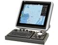
JAN-7201S/9201S
ECDIS
The Electronic Chart Display and Information System (ECDIS) is a geographic information system for voyage planning and route monitoring to support the safety navigation of ships at sea. And in response to the latest revision of the International Convention for the Safety of Life at Sea (SOLAS), the International Maritime Organization (IMO) enforced the mandatory installation of the ECDIS by July 2017 according to vessel’s category.(Requirements for the equipment and operation qualification are subject to approval from the country with which the ship is registered and recommendations from the classification society of the ship.)
The ECDIS onboard a ship uses information from the automatic identification system (AIS) and superposes the images with navigational chart information, thus accurately displaying dynamic information on other ships around. Also the ECDIS plays central roles in the safe navigation of the ship and provides safety functions, including the generation of warnings when the ship approaches dangerous areas. The ECDIS is useful for marine accident avoidance and serves as equipment indispensable to the safe navigation of ships.
Sophisticated user interface
The ECDIS JAN-7201S/9201S incorporates a new user interface (named jGUI) for an intuitive, easy-to-use, simple menu system based on the display of icons. This interface always displays critical data in fixed positions on the screen while icon-based menu display informs users of corresponding functions straightaway. Furthermore,target tracking (TT) and AIS symbols feature pop-up displays while mouseover on the target showing their main data at a glance.
Route editing and safety checking
JRC’s new ECDIS JAN 7201S/9201S has integrated route editing, which was conventionally divided into two segments, i.e., graphics input and numeric table input areas, into one.
Waypoints, if specified, on a navigational chart are immediately quantified and added to the numeric editing table, and the numeric data on the waypoints that is input into the editing table is immediately reflected on the navigational chart.
Up to four routes can be edited at the same time, and a portion cut out of any route can be combined and the routes can be all or partly replaced or edited.
Furthermore, a safety check on edited route data is possible with a click of a button.
Detected error information items, if any, are listed and displayed, and the corresponding route portions are highlighted in the chart and table, which can be confirmed at a glance to take remedial measures.
Regulations and major specifications
This equipment conforms to the requirements set out in the IMO’s resolution MSC.191 (79) for display-related voyage information adopted in December 2004 and the IMO Resolution MSC.232 (82) for ECDIS performance standards adopted in December 2006.
Other specifications of the ECDIS are shown below.
· Electronic chart display function : IEC 61174
· Display-related voyage information : IEC 62288